Standing at 3,153 metres above sea level, Mount Sindoro is one of Central Java's most rewarding volcano treks — a long, steady climb through vegetable terraces, misty forest and open savanna, ending on a broad crater rim with a sunrise that regularly ranks among the best in Java. It is a serious mountain, not a casual day walk, but it is also very achievable for fit hikers with a bit of preparation. This Mount Sindoro trekking guide covers the popular Wonosobo route, what each stage of the climb feels like, where to camp, what to pack, and how to plan your summit morning for 2026.
Most hikers reach Sindoro from Wonosobo, the cool highland town that also serves the nearby Dieng Plateau. From Wonosobo it is a short drive to the trailheads on the mountain's southern and eastern flanks, and the town makes a comfortable base for a night before and after the climb, with simple hotels, warm food stalls and transport connections to Yogyakarta, Semarang and Magelang. If you have never trekked a Javanese volcano before, Sindoro is a good first big one: the trail is well used and well marked, porters and guides are available at the basecamps, and the route is long rather than technical, so steady pacing matters more than climbing skill.
Meet the Mountain: What Makes Sindoro Special
Mount Sindoro (also spelled Sundoro) is an active stratovolcano in Central Java, rising above the Wonosobo and Temanggung regencies. Its twin, Mount Sumbing, stands just across the Kledung Pass to the east — the two peaks are so close that they are often photographed together, and on a clear morning from Sindoro's summit you can look straight across at Sumbing's cone. Do not confuse the two: they are separate climbs with separate basecamps, permits and trails, and this guide covers Sindoro only.
What sets Sindoro apart is the variety of its landscapes. The climb begins among tobacco and vegetable fields worked by highland farmers, passes through dense tropical forest dripping with moss and ferns, then opens out into grassy savanna dotted with edelweiss-like flowers as you gain altitude. Near the top, the vegetation thins to low shrubs and volcanic rock, and the crater itself is a wide, dramatic bowl with sulfur-stained slopes. On a clear day the panorama takes in Sumbing, the Dieng highlands, and a chain of distant Central Java volcanoes fading into the haze.
Sindoro is also a mountain with a strong local hiking culture. On weekends and public holidays the trail is busy with Indonesian student groups and hiking clubs, while weekdays are much quieter. That social atmosphere is part of the charm — basecamps are lively, fellow hikers share tips and snacks, and the summit at dawn feels like a small festival — but if you prefer solitude, aim for a weekday climb.
Sunrise from the summit ridge of Mount Sindoro, above a sea of clouds.
The Wonosobo Route: Kledung and Alang-Alang Sewu Basecamps
The most commonly used starting point for Sindoro from the Wonosobo side is the Kledung area, on the road between Wonosobo and Temanggung, with the Alang-Alang Sewu trailhead nearby. Both serve the same mountain and join the upper trail; local basecamp staff can confirm which entrance is currently operating and where to register. Arrive the afternoon before your climb if you can: register, sort out a guide or porter if you want one, check the weather, and sleep early, because summit day starts long before dawn.
From Wonosobo town, the drive to the Kledung area takes roughly 30 to 45 minutes by car or motorbike, depending on traffic. Public transport exists but is less convenient with a full pack, so most visitors arrange a car through their hotel or a local driver. If you are coming from Yogyakarta, allow around three to four hours to reach Wonosobo; from Semarang or Magelang the journey is shorter. Roads in the highlands are winding but paved, and the scenery — terraced hillsides, tea gardens and village markets — is a pleasure in itself.
At the basecamp you will register your details, pay the entrance and trekking fees, and receive a briefing on current trail conditions. Fees change from time to time and differ for domestic and international visitors, so check the latest figure at the basecamp rather than relying on an old blog post; as a rough guide, budget a modest sum for entry, plus separate costs if you hire a guide or porter. Bring identification, as registration usually requires it, and keep your ticket with you on the trail.
Day-by-Day Itinerary: Two Days, One Summit Sunrise
Most hikers climb Sindoro over two days and one night, which allows a proper night at camp and a dawn summit push. Fit and experienced hikers sometimes complete it as a very long single-day hike, but the two-day plan is far more enjoyable and much safer for a first ascent, because it spreads the altitude gain and leaves a buffer if the weather turns.
Day 1: Basecamp to Camp — Fields, Forest and Savanna
Start in the morning, ideally between 8 and 10 a.m., after a solid breakfast in Wonosobo or at the basecamp. The first section climbs gently through farmland, where farmers tend tobacco, potatoes and cabbages on steep terraces. The path here is wide and easy to follow, and it is worth pausing to look back: the view over the Kledung valley opens up quickly, with Sumbing looming across the pass.
After the fields, the trail enters forest, and the character of the walk changes completely. The air cools, the light softens under the canopy, and the path narrows into a steady, sometimes muddy climb among tall trees, tree ferns and moss-covered rocks. This is the longest feeling section of the day, but it is also the most sheltered, which matters if rain arrives. Take your time, drink regularly, and snack often rather than waiting until you are exhausted.
Higher up, the forest thins into open savanna, and the views return with interest. The main campsites sit in this upper zone, on flatter ground with space for tents and, at the busier camps, small shelters and warungs selling hot drinks, instant noodles and basic supplies in peak periods. Arrive by mid to late afternoon, pitch your tent, eat a warm meal, and rest. Temperatures drop sharply after sunset at this altitude, so change into dry clothes, layer up, and get to sleep early — summit day begins around 2 or 3 a.m.
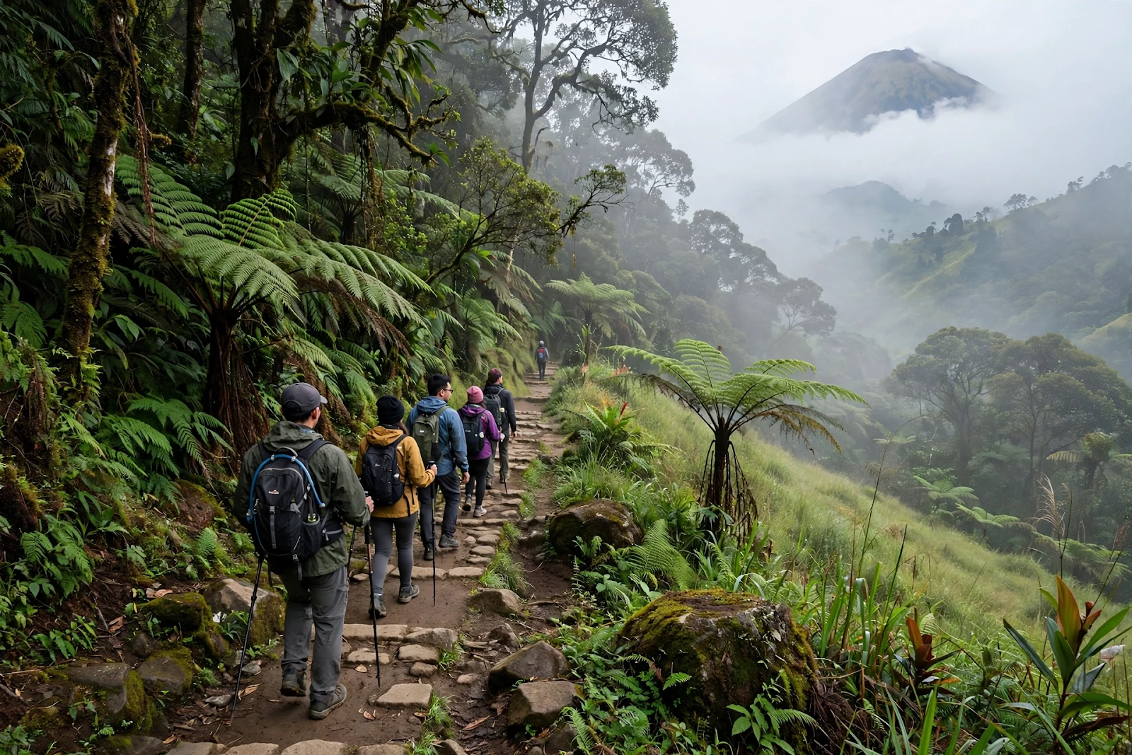
The forested lower trail on Mount Sindoro, climbing through mist and giant ferns.
Day 2: Summit Push, Sunrise and Descent
Wake in the dark, eat something warm and sweet, and set off by headlamp for the final climb. The summit section is steeper and rockier than the lower trail, with loose volcanic gravel in places, so take short, steady steps and watch your footing. The reward builds with every pause to catch your breath: as the sky lightens, the sea of clouds below begins to glow, and the silhouettes of neighbouring volcanoes appear one by one.
Reach the crater rim in time for sunrise if you can. The summit area is broad rather than a single sharp point, so find a safe spot on the rim, away from unstable edges and any sulfur vents, and enjoy the show. On a clear morning the sun rises over a rippling blanket of cloud, with Sumbing close at hand and the Dieng Plateau spread out below. Allow time to walk a short way along the rim for different viewpoints, take photographs, and simply sit with the achievement — you have climbed more than 3,000 metres.
Descend the same way, returning to camp for breakfast and to pack up, then continue down to the basecamp. The descent is long and hard on the knees, especially the steep forest section, so trekking poles help enormously. Most hikers reach the basecamp by mid to late afternoon, tired, dusty and very happy. From there it is a short ride back to Wonosobo for a proper meal, a hot shower and a well-earned rest.
Camps and Water: What to Expect on the Mountain
Campsites on Sindoro are simple, open clearings rather than serviced campgrounds, so bring everything you need: tent, sleeping bag rated for cold highland nights, sleeping mat, stove and fuel if you plan to cook, and enough food for two days. Small warungs at some camps sell hot drinks and instant food when the mountain is busy, but they cannot be relied on, especially on weekdays or in the rainy season, so treat anything you can buy up there as a bonus, not a plan.
Water is the critical planning point. There are water sources at certain points on the lower and middle trail, but they are not guaranteed in the dry season, and the upper camps may have no reliable supply at all. Carry more water than you think you need for day one, refill wherever a trustworthy source is available, and bring a method to treat or filter water if you plan to use stream water. A good rule is to start day one with at least two to three litres per person, plus extra for cooking, and to top up at every safe opportunity.
Leave no trace. Pack out all rubbish, including food wrappers and tissues, use designated toilet areas where they exist, and keep a respectful distance from other campers' tents at night. Sindoro's trails stay beautiful because hikers look after them, and the farming communities at the foot of the mountain deserve the same courtesy on the way down as on the way up.
The Summit Sunrise: Getting the Best of It
Sindoro's sunrise is the reason most people make the climb, and a little planning makes it far better. First, protect your summit morning: sleep early at camp, lay out your warm layers and headlamp the night before, and set more than one alarm. Second, dress for wind as well as cold — the crater rim is exposed, and a windproof jacket over your warm layers makes the difference between enjoying the sunrise and shivering through it.
Third, be patient with the weather. Cloud can hide the sunrise even on a promising morning, and it sometimes clears suddenly after dawn, revealing views that early risers who left too soon will miss. If conditions are safe, linger on the rim for a while after sunrise rather than rushing down. Finally, remember that the summit is a volcanic environment: stay on established ground, keep away from crater edges and sulfur fumes, and follow any instructions from guides or basecamp staff about restricted areas.
The broad crater of Mount Sindoro, with the terraced highlands of Central Java spread out below.
Permits, Guides and Costs
Registration at the basecamp is mandatory, and you should also check current conditions before you go: volcanic activity, weather warnings and temporary closures can all affect access, and local authorities occasionally close trails during extreme weather or for conservation reasons. A quick check with the basecamp or a Wonosobo hotel the day before your climb is the most reliable way to confirm that the mountain is open.
Guides are not always compulsory for experienced groups, but they are strongly recommended for first-time visitors, solo hikers and anyone unfamiliar with Indonesian volcano trails. A local guide knows the current state of the path, the water points and the weather patterns, and hiring one supports the communities around the mountain. Porters can also be arranged at the basecamp if you want to lighten your load; agree the fee, the load and the itinerary clearly before setting off.
Costs are modest by international trekking standards. Expect to pay entry and registration fees at the basecamp, plus transport to and from Wonosobo, food, and guide or porter fees if you hire them. Prices vary with the season and group size, so confirm each cost in person and carry cash in small notes, as card payments are rarely available at basecamps and on the trail.
Packing List for Sindoro
Pack light but complete. Essentials include sturdy, broken-in hiking boots with good grip, a comfortable daypack plus a larger pack if camping, a warm jacket, a windproof and waterproof outer layer, a hat and gloves for the summit morning, and a headlamp with spare batteries. Add sunscreen and sunglasses for the exposed upper slopes, where the sun is strong even when the air feels cool.
For camping, bring a tent, a warm sleeping bag, a sleeping mat, a stove and fuel, a lighter, cooking gear, and food that is simple to prepare at altitude — instant noodles, rice, canned food, bread, snacks, coffee or tea, and plenty of drinking water. A basic first-aid kit, any personal medication, blister care, a power bank, and a dry bag for electronics round out the list. Trekking poles are highly recommended for the long descent, and gaiters help in muddy conditions during the rainy season.
Best Season to Climb Mount Sindoro
The best time to climb Sindoro is generally the dry season, roughly from April or May through October, when trails are firmer, rain is less frequent, and clear sunrises are more likely. July to September are the most popular months, which means busier trails but also the best chance of a cloud-free summit morning. The rainy season, roughly November to March, brings slippery paths, leeches in the forest, and a much higher chance of clouded-out views — the mountain is still climbable for experienced hikers, but it is a wetter, muddier and less predictable undertaking.
Whatever the season, mountain weather changes fast. A clear afternoon at camp can turn into a windy, rainy night, and a cloudy dawn can clear by mid-morning. Check the forecast, but pack for rain and cold even in the dry season, and be ready to turn back if conditions become unsafe. No sunrise is worth a dangerous climb.
Safety Tips for a Sindoro Trek
Sindoro is a demanding hike with more than 1,500 metres of elevation gain from the trailhead, so fitness matters. Train with hilly walks carrying a loaded pack in the weeks before your climb, and pace yourself on the mountain — slow and steady beats fast bursts followed by long rests. Drink and eat regularly, watch for signs of altitude discomfort such as persistent headache or nausea, and descend if symptoms worsen rather than pushing on to the summit.
Other safety basics apply as on any volcano trek: tell someone your plan and expected return time, stay on the marked trail, carry a charged phone and a power bank but do not rely on signal, and keep your group together in bad weather or darkness. Start early, respect closure signs and guide advice, and remember that the descent is where most injuries happen — tired legs, loose gravel and steep steps demand just as much care as the climb up.
Sponsored: see today's best travel deals and offers
Frequently Asked Questions About Mount Sindoro
How high is Mount Sindoro?
Mount Sindoro rises to about 3,153 metres above sea level, making it one of the higher volcanoes in Central Java. The climb from the Wonosobo-side trailheads involves well over 1,500 metres of ascent, which is why most hikers spread it over two days.
How long does it take to climb Mount Sindoro?
Most hikers take two days and one night: a full day to reach the upper camps, an early-morning summit push for sunrise, and a descent back to the basecamp on day two. Very fit and experienced hikers can complete it in a single very long day, but the two-day plan is more enjoyable and safer for most people.
Do I need a guide to climb Mount Sindoro?
Guides are not always compulsory, but they are strongly recommended for first-time visitors, solo hikers and anyone unfamiliar with Indonesian volcano trails. A local guide knows the current trail conditions and water points, and hiring one supports the communities around the mountain. Porters can also be arranged at the basecamp.
What is the best time of year to climb Mount Sindoro?
The dry season, roughly April or May through October, is generally the best time, with firmer trails and a higher chance of clear summit sunrises. July to September are the most popular months. The rainy season from around November to March brings slippery trails and cloudier views, and is best left to experienced hikers.
Is Mount Sindoro the same as Mount Sumbing?
No. Sindoro and Sumbing are twin volcanoes standing either side of the Kledung Pass, and they are often photographed together, but they are separate mountains with separate trails, basecamps and permits. This guide covers Sindoro only; if you want to climb Sumbing as well, plan it as a separate trek.
Mount Sindoro rewards every step of its long climb: the quiet forest mornings, the open savanna afternoons, the cold starlit night at camp, and finally that golden sunrise above the clouds. Plan well, pack for cold and rain, respect the mountain and the communities at its foot, and you will come down with one of Central Java's great trekking memories. Have you climbed Sindoro, or is it on your list for 2026? Share your experience, your questions and your own summit tips in the comments below — and tell us which Central Java peak you would like us to cover next.




Comments
Post a Comment